What do you want to see?
Village · The Krk Map
Stara Baška
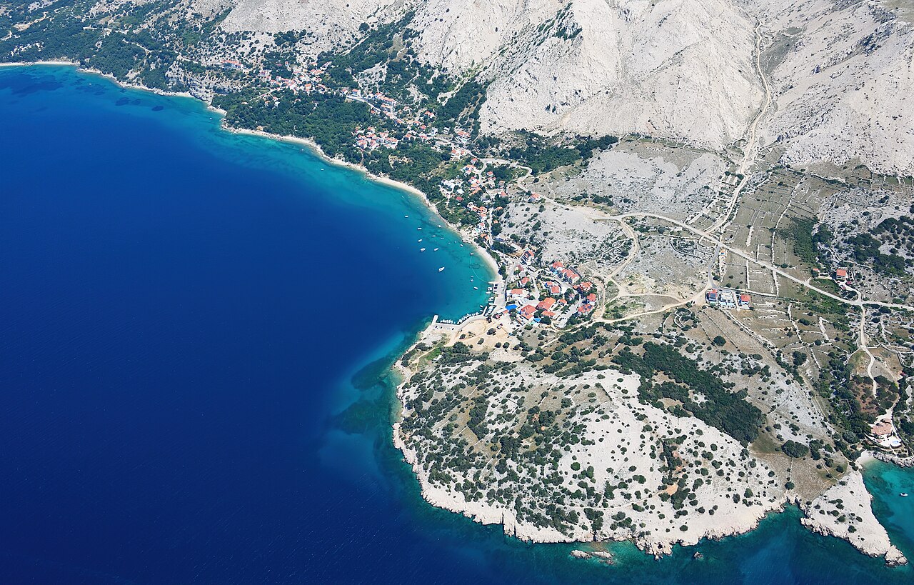
A tiny shepherds' village at the end of the road: a harbour, steep lanes up to the church and the hilltop cemetery, and coves on every side.
Open this guide on The Krk Map
Quick answers
Where can I eat and drink in Stara Baška?
The choice is small and seasonal: the big terrace of Mariana above the harbour looks straight into the sunset, and Malena konoba by EOLA on the Mul grills local dishes outdoors. The Škrila beach bar is our pick for a cocktail with a view; from mid-September, check which places are still open.
Where can I swim in Stara Baška?
Below the houses at the village beaches and the Barčica coves below the church (water shoes: the entry is pebbly). Over the headland, about 20 minutes on foot, Zala is a white-pebble cove with a cold spring and a small bar; across the bay, Camp Škrila's beach has about 1 km of shore with dog and naturist sections.
Where can I park in Stara Baška?
There is small paid street parking at the harbour (about 20 spaces) and a free unpaved car park on the east side of the village. Zala has two pay car parks, EUR 1 an hour (May to September) and EUR 1.40 an hour (June to September, 2025); above Oprna, park with all four wheels off the asphalt and never in a bend.
Is Stara Baška good with small children?
The village is steep, with steps everywhere and no pavements, so it is not easy with a pushchair. Zala works for families: 5–10 m out the bottom turns to sand, like a pool. On the coastal path below the church one section has broken away and has a temporary safety rope (2026): hold children's hands.
Is there a supermarket or pharmacy in Stara Baška?
No: the village has two small shops for the basics but no pharmacy, doctor, bank or supermarket. The nearest pharmacy and health centre are in Punat, about 17 minutes away, and Camp Škrila has a small shop and an ATM.
Stara Baška is where the road from Punat gives up: about 120 residents (2021), a 14th-century shepherds' settlement, one small harbour and a steep village of stone lanes that runs up to the parish church and the cemetery. Nothing here is organised for you, which is the point. The days are built from short walks: down the steps to a cove, over the headland to Zala, up the lane to the church, back to the harbour for a drink as the light goes. It suits couples and families who want quiet and water more than restaurants and shops; anyone who needs nightlife, a pharmacy or a supermarket drives 17 minutes to Punat.
When to come: Swimming June to September. Restaurants and bars are seasonal: from mid-September, check which are still open before you plan dinner.
What to do
Climb behind the village at dawn for the view back over the bay
The marked trail that starts inside the village climbs steeply for about 30 minutes; then the view opens back over Stara Baška, the camp and the bay. Fit walkers carry on over the plateau to Veli Hlam (482 m), Stara Baška's home mountain, past the Jasenova cave and old bauxite pits.
- Where
- The marked trail from the village guidepost up towards Jasenova; the viewpoint is about 240 m up, with Veli Hlam beyond.
- When
- Start by 07:00 from June to August; any time of day in spring and autumn
- Time
- About 1 h up and back for the view; about 3.5 h for the Veli Hlam loop (KRK HIKE 147: 9.2 km, 400 m of climbing, rated difficult)
- How
- Waymarked path, steep and rocky at first, then karst plateau. No shade and no water. Hiking shoes and 2 litres each.
First swim of the day below the village houses
A swim from the small pebble beaches along the village shore, before anyone else is up. The main village beach is Slatina; there is also a town beach just north of the harbour, and the Barčica beaches further north.
- Where
- The village shore between the harbour and Barčica; the town beach is just north of the harbour.
- When
- Early morning, June to September
- Time
- 30–60 min
- How
- On foot: steps lead down between the houses. Many lanes end in steps down to the water.
Tip: Wear water shoes: the entry is pebbly. Dogs are not allowed on the town beach; the dog beach is at Camp Škrila.
Walk or drive over to Zala, the beach on the other side
Zala lies over the headland to the south-east: a white-pebble cove with a cold freshwater spring and a small bar, reached on foot or by car to the paid car park above it. It is the last beach you can drive to; beyond it the gravel road is for walkers only. Across the bay to the north-west, the Škrila camp beaches have their own bar; walk or drive.
- Where
- Zala, over the headland south-east of the village; Škrila across the bay to the north-west.
- When
- Zala before 10:30 or after 16:00 in July–August; any time in May–June and September
- Time
- Zala about 20 min on foot over the headland; Škrila about 2 km on foot round the bay
- How
- Zala on foot: village lanes, then the gravel track over the headland. By car (3 min): the narrow road ends at two small pay lots, EUR 1/h from May to September (lower) and EUR 1.40/h from June to September (upper); both were charging in September 2025. Škrila by car (5 min): the camp car park is for customers, EUR 13/day.
Tip: At Zala, jump from the rock on the left and scramble right over the rocks to tiny private-feeling coves. Then walk five minutes up to the St Jerome church ruin.
The Petehova evening loop
An easy 2.5 km round from the harbour: south along the rocky coast past Rt Klobučac to Petehova cove, with its two small pebble beaches and a lone villa above, then back up to the road and into the village. Sage and Mediterranean herbs flower in spring, sheep roam free, and the view runs to Rab and Goli otok.
- Where
- Starts at Stara Baška harbour; the rocky coast path runs south to Petehova bay.
- When
- Evening or early morning; spring for the flowers
- Time
- 1–1.5 h walking, about 50 m of climbing
- How
- Easy: a rocky path along the coast, the road on the way back. Trainers, not flip-flops.
Tip: Parts of the path can be overgrown, and the water off the cove gets deep almost at once. The villa above Petehova is private: keep to the path past the house.
Walk up to the church and the hilltop cemetery
The short climb through the upper village (Gori selo) to Stara Baška's cemetery on the hill, in use since 1855. The parish church of All Saints is a separate stop down in the village: an octagonal church begun in 1847, with parish books from 1856. The lane beside the church is called Cimiter, the local word for cemetery, because the old churchyard cemetery was there before the hill cemetery opened.
- Where
- The cemetery on the hill above the upper village; the church of All Saints stands separately, in the village below.
- When
- Late afternoon or early evening; the slope faces west over the bay.
- Time
- About 12–15 min up from the seafront (about 70 m of climbing); 45 min in all
- How
- On foot on asphalt village lanes, no path-finding needed. From the harbour: Mul, Vrbakane, Na Palti, Pod Bratomore, then the short service road to the cemetery gate.
Tip: Don't go back the way you came: from the church, concrete steps drop down the far side of the hill to the little coves. The cemetery is in use; keep it quiet.
Down the steps on the far side to the little coves
From the All Saints church, stairs lead down the north side of the hill to a string of small pebble coves below the upper village. The one at the foot of the stairs is Pod brizi; Pod Goricu is about 220 m further on, with Pod Selo and Pod Perovica nearby, all linked by coastal and woodland paths. On maps this shore is Plaža Barčica, with several smaller pebble beaches.
- Where
- The shore below and west of All Saints church, down to Barčica beach.
- When
- Any time in summer; best combined with the cemetery walk in the late afternoon
- Time
- About 290 m (5 min) down from the church to Barčica
- How
- Concrete steps and a concrete coastal path from the church down to the water; then walk back along the shore path towards the harbour.
Tip: Swim at the cove, then take the coastal path home instead of the lanes. One short section of the concrete path has broken away and has a temporary safety rope (2026): fine for adults in shoes, hold children's hands.
Sundowner cocktails at the Škrila beach bar
A small bar on the pebble beach of Camp Škrila, our pick for a cocktail with a view, facing west across the bay.
- Where
- Inside Camp Škrila, at the village entrance.
- When
- Sunset; in season the bar is open daily 09:00–23:00.
- Time
- 1–2 h
- How
- About 2 km on foot through the village and the camp, or 5 min by car. The camp car park is for customers (about EUR 13/day); ask at the gate whether you can drive in for the bar.
Tip: The walking route follows the 5125 road for part of the way, so after dark drive or arrange a lift. The camp also has an ATM and a small shop, useful because the village has neither a bank nor a big shop.
A drink on Mariana's terrace as the sun goes down
The big, partly covered terrace above the tiny harbour, looking out over the Kvarner. Come for a drink at sunset; if you stay to eat, the kitchen does fresh fish, the grill and peka cooked over an open fire outdoors.
- Where
- Stara Baška 254, above the harbour.
- When
- The hour before sunset. In season it opens daily 08:00–23:00 (2026), so it also works for a morning coffee.
- Time
- 1 h for a drink; 2 h for dinner
- How
- On foot from anywhere in the village. Reserve by phone (+385 91 571 1261) or through the form on its website.
Tip: It stays open late into the season. Ask what is fresh that day, and for the peka, ask when you book how much notice the kitchen needs.
Walk to Baška over the Vratudih pass (one way)
The classic crossing between the two Baškas: up bare, bura-scoured slopes to the Vratudih pass (about 350 m), past the flower-shaped dry-stone sheep pens (mrgari) at Vratudih, then down through Batomalj into Baška for a swim and lunch.
- Where
- The marked trailhead is about 200 m inside the village from the entrance; the path climbs to the Vratudih pass.
- When
- Spring and autumn, early start; summer only at dawn; never in bura
- Time
- About 8 km one way, 3–4 h
- How
- Follow the waymarks of the 'Baška - Stara Baška' route; it is rated difficult. Arrange the pick-up in Baška before you go.
Tip: Pack swimwear and finish at Baška's Vela plaža.
Oprna: park with all four wheels off the tarmac, or use the camp car park
Park on the prepared roadside above Oprna with all four wheels off the asphalt and never in a bend: cars on the road have been ticketed. Come early, as the spaces fill up. Camp Škrila's paid car park nearby (about EUR 13/day in 2025) is the alternative; ask at the gate.
- When
- June to September, above all mornings in July and August
Tip: If there's no space, use the camp car park and walk.
Oprna beach day: be there by 09:30, bring shoes, cash and your own shade
A few paths run 10–15 minutes down from the road. You climb over the guardrail and drop about 50 m on rough rock. The beach has a drinks-only kiosk that takes cash only, no toilets, and only a handful of rental umbrellas by the bar.
- When
- Arrive before 09:30 in July and August; crowded from about 11:00
Tip: Trainers or hiking sandals, not flip-flops. Bring an umbrella, water and food. The few rental sets (about EUR 30 for an umbrella and two loungers in 2025) are paid in cash.
On foot past Zala: the St Jerome ruin and the next bays
Past Zala the gravel road is for walkers only: leave the car in the paid car park above Zala and walk on past the ruined church of St Jerome (Sv. Jerolim) to the next bays.
- When
- Any time; best early or late in the day (no shade)
Tip: Wear good shoes and carry water: there is no shade beyond Zala.
Village watch-out: one narrow lane, no pavements, steps down to the sea
The road through the village is so narrow that oncoming cars can barely pass. From the church it drops to the harbour. There are no pavements, and most houses reach the sea by steep steps.
- When
- July and August especially
Tip: Drive in slowly and be ready to reverse to a wider spot for oncoming cars. Not a village for prams.
A half day here
- 08:00 swim below the village houses (water shoes).
- 17:30 walk up Na Palti and Pod Bratomore through the upper village to the cemetery hill (12–15 min) for the view back over the bay.
- 18:00 take the steps down the far side to the Barčica / Pod brizi coves for a last swim.
- Walk home along the coastal path (mind the roped section) and finish with a drink on Mariana's terrace as the sun goes down.
- Alternative morning: walk over the headland to Zala (about 20 min), swim, climb five minutes to the St Jerome ruin, and have a coffee at the Zala bar before walking back.
Where to eat and drink
- Restaurant Mariana: The harbour terrace for a sunset drink; open late into the season.
- Škrila beach bar: Our pick for a cocktail with a view, on a west-facing pebble beach at Camp Škrila.
- Malena konoba by EOLA: Small seasonal konoba on the Mul by the harbour, run by the family behind the former Nadia; check opening times.
Where to swim
- Stara Baška village beaches: The morning swim below the houses; also the Barčica / Pod brizi coves below the church.
- Zala Beach: Over the headland: a cold spring, a jump rock, a bar and a pay car park.
- Camp Škrila beach: Across the bay: a kilometre of pebble with the Škrila bar, a dog section and a naturist section.
- Petehova coves: Two tiny pebble coves on the evening loop; a private villa overlooks them.
Practical
Parking
Small paid street parking at the harbour (about 20 spaces) and a free unpaved car park on the east side of the village. Zala has two pay car parks (EUR 1/h May–Sep, EUR 1.40/h Jun–Sep; 2025). Never park on the Oprna road with a wheel on the asphalt.
Shops, cash and the Sunday situation
Two small village shops for the basics; check their Sunday hours. Camp Škrila has a small shop (cash) and an ATM; there is no bank in the village. For a full shop, go to Punat.
Pharmacy and doctor
None in Stara Baška. The nearest pharmacy and health centre are in Punat (about 17 min); the next emergency clinic is in Krk Town.
Toilets and water
Public toilets at the harbour. A free public drinking-water tap in the village, where you can fill bottles.
Seasonality
Most of the village's restaurants and bars are seasonal, and by late September only a few are still open: check before you plan dinner.
Getting out without a car
Ask the Punat tourist office about buses before you rely on one. A taxi boat from Punat needs about an hour to come round to Stara Baška, and that time is part of the price.
Watch out
- The village is steep: steps everywhere, few level paths. Not easy with a pushchair or for guests with limited mobility.
- One section of the concrete coastal path below the church has broken away and carries a provisional safety rope.
- No pharmacy, doctor, bank or supermarket in the village; plan the Punat run.
- Hikes behind the village have no shade and no water: dawn only in July and August, and never in bura.
Curated by Benjamin Haller and our guests · Facts checked 31 Oct 2026 · How this map is made
The Krk Map is made by Marim Luxury Villas, a family company that hosts guests in Stara Baška and Vrbnik. No place pays to be on it; partners and our curators’ own offers are marked. Our villas