What do you want to see?
Area · The Krk Map
Baška mountains: the Moon plateau, Hlam, Obzova and the Glagolitic path
The island's big walking country: a bare 'moon' plateau of sheep walls above Baška and the island's highest summit, best walked at dawn and dangerous at noon in July.
Open this guide on The Krk Map
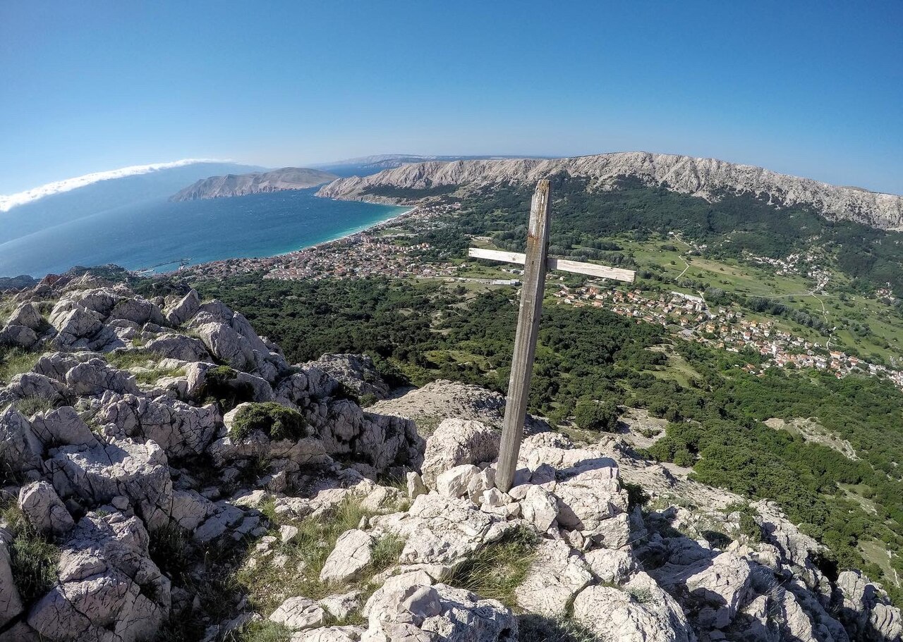
Above Baška the island turns into bare, pale limestone: a plateau of dry-stone walls and flower-shaped sheep pens that really does look like the moon, a string of 460–570 m summits, and griffon vultures overhead. It is serious walking country, with views from Velebit to Rab, Cres and the Rijeka bay, and in July–August it is also genuinely dangerous: no shade, no water, sharp rock. Walk it at first light or in spring and autumn. Fit couples, groups of friends and families with older children will love it; grandparents can walk the shaded forest section to the plateau gate and turn back with the best of the view already seen.
When to come: April–June and September–October are ideal. July–August only from first light until about 10:00. Winter is fine on days without strong bura.
What to do
Walk up to the Moon plateau at first light
Baška's signature walk. From St John's church above town a built path climbs through dense pine forest, in shade all the way, with benches at the best viewpoints and three sharp switchbacks, to a gap in a dry-stone wall. Beyond it the bare, eroded limestone plateau opens at about 370 m, with views over Prvić, Rab, Sveti Grgur, Goli otok and Velebit. From Hotel Forza in the centre it is about 4.5 km to the plateau; from the church about 3 km, an hour up and 30 minutes down.
- Where
- Start at St John's church above Baška; the plateau viewpoint is on Stražica (372 m).
- When
- July and August: start at first light (sunrise about 05:15 in late June, 06:00 in mid-August) and be back in the forest by about 10:00. April to June and September to October: any cool hour.
- Time
- 2 h return from St John's; 2.5–3 h from the centre
- How
- Park at St John's (very few spaces) or in a town lot and walk up. Built forest path, then sharp rock. No water anywhere: carry 2 litres or more per person. Proper shoes, not sandals.
Tip: Rest at the last shade before the wall: after it there are no trees for a long stretch. Close the pasture gate behind you: the plateau is sheep pasture, and on hot days the flocks shelter in the forest. For less mobile guests, the forest section alone gives the views from the benches without the exposed rock.
Carry on to Hlam (461 m), and come back the way you came
From the plateau you can continue to Hlam, the stone-pyramid summit above Baška, for the full sweep of the Kvarner islands. The marked route from Hotel Forza in the centre is about 7.5 km and 3 hours one way; you come back the same way, so plan a long morning.
- Where
- Hlam summit (461 m) above Baška, beyond the Moon plateau.
- When
- Same heat rule: dawn in summer, any cool time in spring and autumn.
- Time
- About 5 h return from the centre
- How
- Follow the markings from the plateau; they are non-standard (white-yellow-blue) and easy to lose. Load the GPX of KRK HIKE 169 from krk-outdoor.hr before you go.
Tip: Return through the shaded pine forest rather than on the official loop's descent via Zakam: that side drops steeply on eroded rock through a canyon. Don't confuse this Hlam (461 m) with Veli Hlam (482 m) above Stara Baška.
The long day: Diviška pond, the walls that shared the water, and the old mrgari
Past the main plateau a longer out-and-back reaches Diviška pond at about 450 m. Its dry-stone walls were built so that five owners' flocks could drink without mixing. Diviška peak (471 m) above it looks over the Velebit channel towards Senj. On the way you pass two old sets of mrgari ('Na starih mrgari') on the plateau.
- Where
- Diviška pond, past the Moon plateau above Baška; the walk starts at St John's church.
- When
- Spring and autumn; in summer only if you start at dawn. Winter on days without strong bura.
- Time
- 12–13.5 km, 3.5–4 h walking, about 5 h with breaks
- How
- From St John's church on yellow markings: forest, then a gravel track and rocky plateau. Return the same way. Treat the pond as livestock water, not drinking water.
Tip: You are inside the Kuntrep ornithological reserve, protected since 1969: bring binoculars for griffon vultures. Strong walkers can turn it into the 20 km 'Baška's Rocky Challenge' via Vela Luka (KRK HIKE 171).
Look up: griffon vultures over the Kuntrep reserve
The eastern massif above Baška is raptor country. The Kuntrep ornithological reserve, protected since 1969, covers about 1,000 ha between Cape Glavine and Mala Luka and is a griffon vulture habitat; look out too for eagle owl, peregrine, kestrel and raven. Prvić opposite, a reserve since 1972, holds vultures too.
- Where
- Plateau and summits: Hlam, Diviška, Veli vrh; reserve between Cape Glavine and Mala Luka.
- When
- Any walk on the plateau or the summits; vultures soar once the day warms up and the thermals rise.
- Time
- Part of any plateau walk
- How
- Bring binoculars; stay on the paths.
Tip: Sightings are a matter of luck. This is a protected reserve for nesting vultures: please don't fly a drone here.
Stand on Krk's highest point: the Obzova loop from Treskavac
Obzova (568 m) is Krk's highest point: a stone pyramid, a marble plaque, views from Učka and Rijeka bay to Velebit, Cres, Lošinj and Rab. The loop from Treskavac pass (about 320 m) via Brestovica (558 m) and Veli vrh (542 m) is 9.4 km with 320 m of climbing, about 3 h (KRK HIKE 145).
- Where
- Start at the Treskavac pass car park.
- When
- Spring and autumn; in summer early morning or late afternoon. Avoid strong bura days: the summit has no shelter.
- Time
- About 3 h (9.4 km)
- How
- Park at Treskavac pass; follow the boards. Sharp limestone all the way: trainers or boots.
Tip: The summit is a stamp point of the Croatian mountaineering circuit, with a stamp box; bring a notebook for children to stamp. Pack a windproof even in August and at least 2 litres of water each. Pair it with the zipline at the same car park.
Collect the 34 stone letters of the Baška Glagolitic path
An open-air alphabet of 34 carved Glagolitic letters, placed in 2006–2009 from the 6 m letter A at Treskavac pass through Draga Bašćanska, Batomalj and Jurandvor to the beach, the harbour and Cape Kričin. It is not one trail: hop between them by car, bike or on foot. Each letter is sponsored by a place or firm with that initial (Prague sponsors P); the plaques include Braille. An extra sculpture honours the Sinjali society.
- Where
- Across the Baška valley, from the letter A at Treskavac pass down to Cape Kričin above Bunculuka.
- When
- Any season; in summer do the walking parts in the morning.
- Time
- Half a day spread over car stops and short walks; or 11 km by bike
- How
- Pick up the trail map or guidebook at the Baška tourist office. By bike: the easy KRK BIKE 451 (11.3 km, 157 m of climbing) links most of the valley letters. There are also guided tours of about 2 hours.
Tip: Give children the booklet and a crayon: they rub each letter from the small plaque beside it. Try spelling their names in Glagolitic, then find the same letters on the tablet replica at St Lucy's. Four of the big letters are by the sculptor Ljubo de Karina.
A half day here
- 05:45 (July–August) or 08:00 (spring/autumn): start at St John's church above Baška.
- 06:45 Rest at the last shade, go through the dry-stone gate and walk out onto the plateau to the Stražica viewpoint.
- 07:30 Take the photos and turn back, or, if you are fit and carrying water, go on to Hlam and plan a longer morning.
- 09:30 Back down through the pine forest the same way.
- 10:30 Swim at Vela plaža or take the taxi boat to Vela Luka, then a long lunch in the shade.
Where to swim
- Baška Vela plaža: The easy after-hike swim at the foot of the St John's path.
- Vela Luka: For the long day: walk out over the hills, swim, and take the taxi boat back.
Practical
Trailheads and parking
Moon plateau, Hlam and Diviška: St John's church (a handful of roadside spaces) or the town car parks, then walk up. Obzova, Vela Rika and the letter A: the Treskavac pass car park on the D102. Bag and the south-west ridge: Zarok at the end of Vela plaža.
Water, shoes and heat
No water on the plateau or the summits; the ponds are for livestock. Carry at least 2 litres each, and up to 4 litres on the long southern loops, even in June.
Maps, markings and GPX
The island tourist board's krk-outdoor.hr publishes each route with a KRK HIKE number and GPX (169 Moon and back, 171 Rocky Challenge, 163 Obzova from Draga, 167 Bag). Markings on the Moon plateau are non-standard and easy to lose on the way down.
Emergencies
Call 112 (mountain rescue is dispatched through it). The nearest summer doctor is the tourist clinic at the Sunny Baška Hotel.
Watch out
- Heat: the plateau, Hlam, Obzova and the ridges have no shade and no water. In July–August midday walks here are a real sunstroke risk.
- Sharp limestone: proper shoes, no sandals or flip-flops.
- The official loop's descent from Hlam via Zakam is steep eroded rock; return the way you came.
- Markings are non-standard and easy to lose on the way down; carry the GPX.
- Bura makes the summits and the plateau cold and gusty even in summer; avoid strong-bura days.
- The forest path is also a popular mountain-bike trail: step aside for riders.
Curated by Benjamin Haller and our guests · Facts checked 31 Oct 2026 · How this map is made
The Krk Map is made by Marim Luxury Villas, a family company that hosts guests in Stara Baška and Vrbnik. No place pays to be on it; partners and our curators’ own offers are marked. Our villas